My World in Ink

  • Startseite
  • Pen and Ink
    • Pen and Ink – My World
  • Reiseberichte
    • West Highland Way 2004
    • Schottland 2005
    • Offa’s Dyke 2006
    • Cleveland Way 2010
    • Guernsey 2012
    • Pennine Way 2017
    • West Highland Way 2017
    • Great Glen Way 2017
    • USA 2018
      • Seattle & Olympic Peninsula
      • Pacific Crest Trail – Washington
    • Pacific Crest Trail 2019
  • Kontakt
    • About Ink
  • Blog

Alston – Greenhead

31. Juli 2017


Dauer: 6,5 Stunden
Strecke: 23,8km
max. Höhe: 273m
Aufstieg: 175m


Die Nacht war eher unruhig weil verregnet, aber morgens ist blauer Himmel zwischen den Wolken zu sehen und ich kann im Trockenen einpacken.

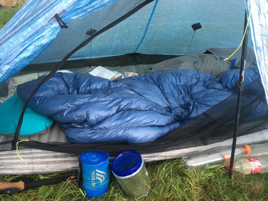
Gestern Abend ist hier noch ein Mädel angekommen und wir quatschen kurz, bevor ich loslaufe und mir beim co-op Sandwiches zum Frühstück besorge. Sie hat offensichtlich als sie gestern Abend duschen war Besuch von Nagern im Zelt gehabt, die Interesse an ihrer Tüte mit Essen hatten. Das schlimmste daran ist nicht, dass sie das Essen entsorgen musste, sondern ein Loch im Innenzelt, das die Viecher hinterlassen haben. Ärgerlich.

Ich bin froh, dass ich mein Essen in einem geruchsdichten Opsak/Loksak-Beutel aufbewahre und keinen Besuch hatte. Wie gesagt, der Campingplatz ist das letzte.

Gestern Abend hat sich Christian gemeldet und geschrieben ich soll auf dem ersten Stück aus Alston raus nicht den Pennine Way nehmen, sondern den „South Tyne Trail“, um den größten Matsch zu vermeiden.

Der „South Tyne Trail“ verläuft entlang einer stillgelegten ehemaligen Bahntrasse, auf der mittlerweile eine kleine Strecke wieder neu ausgebaut wird. Vielleicht ist das ähnlich wie in Rawtenstall gedacht, wer weiß.

Letztlich bleibe ich heute auf dem Tyne Trail und laufe ab „Featherstone Station“ über Landstraßen nach Greenhead, wo ich in einer umgebauten Scheune übernachte.

Abends taucht das englische Pärchen auf, das superschnell unterwegs ist und campt hinter der Barn. Abends gehen wir in den Pub und lassen den Tag dort ausklingen.


duration: 6,5 hours
distance: 15 miles
max. height: 895 feet
ascend: 575 feet


Night has been uneasy and rainy but in the morning there is blue sky and some clouds so I can pack up dry.

Yesterday evening another female walker arrived and we have a quick chat before I leave. While having a shower yesterday rodents found their way into her tent and to her foodbag. While the loss of food is just uneasy the hole they left in the inner tent is more than annoying so she was pissed. As I said before, this place is a mess and I am happy I store my food in an odourproof Opsak/Loksak.

Christian textet me that I should not take the Pennine Way out of Alston to avoid the mud. So instead I walked the „South Tyne Trail“ that follows a disused railway track. From Alston to Slaggyford there is a small fairly new railway and they seem to extend that further on. Maybe this some day will result in something like they have in Rawtenstall with that local train line.

I follow the Tyne Trail and roadwalk to Greenhead from „Featherstone Station“ where I stay in a converted barn.

The fast walking couple I met before arrives in the afternoon and camps outside the barn. We spend the evening at the nearby pub.


Filed Under: Pennine Way 2017

Langdon Beck YHA – Dufton (Alston)

30. Juli 2017


Dauer: 6,45 Stunden
Strecke: 21,5 km
max. Höhe: 584m
Aufstieg: 395m


Heute habe ich gut geschlafen und nach dem Frühstück geht es dann auch direkt los.

Der Weg verläuft zunächst über Weideland, was mir ziemlich bald schon das erste Mal nasse Füße beschert.

Schafe sind nie ein Problem, die maulen zwar rum, hauen aber letztlich frühzeitig ab. Kühe sind da anders. Die gucken einen zwar schon vom weiten an, bleiben aber stoisch stehen. Wenn überhaupt reagieren die in letzter Sekunde und dann sehr hektisch. Auf einer dieser Weiden sind ne Menge Kühe. Ich traue den Viechern grundsätzlich nicht und da der Bauer ein Schild angebracht hat, dass auch ein Bulle auf der Weide steht, laufe ich im großen Bogen um die Herde herum. Nasse Füße hin oder her.

Anschließend geht es wieder direkt am River Tees entlang in ein schönes Tal hinein. Das Wetter ist prima und es macht Spaß, in dieser herrlichen Landschaft zu laufen. Irgendwann beginnt der Weg, steiniger zu werden und schließlich geht ohne Klettern nichts mehr. Aber auch das ist schnell vorbei und es geht normal weiter.

Später macht der Fluß einen Rechtsknick und bald darauf kommt „Cauldron Snout“ in Sicht- und Hörweite, ein weiterer Wasserfall. Die nächste Klettereinlage führt rechts vom Wasserfall die Wand hinauf, wo schließlich eine Brücke und die Staumauer des „Cow Green Reservoir“ warten.

Weiter geht’s ab jetzt hier oben, der Weg führt bald über einen breiten Schotterweg, der vermutlich noch nicht allzu alt ist immer bergan über ein Hochmoor hinweg. Irgendwann verlässt der Pennine Way den Schotterweg und es geht ein letztes Mal wieder hinunter zum River Tees.

Die nächste Brücke wartet und dann geht es bergan Richtung „High Cup Nick“, dem Höhepunkt des Tages. Bevor ich dort ankomme, fängt es richtig heftig an zu regnen und ich kann nur hoffen, dass das vorübergeht, bis ich dort angekommen bin.

Schwein gehabt! Es hört wirklich auf, die Regenwolken ziehen ab und ich kann „High Cup Nick“ bei lockerer Bewölkung im Trockenen und sogar mit ein bissl Sonnenschein hier und da bewundern! 🙂

Das Besondere am High Cup ist, dass man zunächst auf eine Hochebene hinaufläuft und dann plötzlich vor diesem imposanten Taleinschnitt steht. Fühlt sich an als wäre die Erde vor einem unvermittelt weggebrochen.

An der rechten Flanke entlang steige ich Richtung Dufton ab und habe Glück, dass ich mir dort ziemlich schnell ein Taxi nach Alston organisieren kann. Der Abschnitt von Dufton nach Alston ist mit der anstrengendste des ganzen Pennine Way und da ich im Anschluss noch in Schottland wandern möchte, erspare ich meinem Knie diese Tortur lieber.

In Alston wartet beim „Tyne Willows Caravan Park“ ein Paket auf mich. Das ist im Nachhinein aber auch der einzige Grund, hierher zu kommen. Der Park ist der schlechteste aller Campingplätze, die ich bisher besucht habe. Dreckig, Schrottplatz nebenan, komische Leute… was solls, Augen zu und durch.


duration: 6,45 hours
distance: 13.5 miles
max. height: 1915feet
ascend: 1295feet


Slept well tonight and headed out after having breakfast.

Crossing some meadows usually makes for an easy start but not today. While sheeps normally moan but move when you come closer, cows don’t. They tend to stare at you but they don’t move until the very last second and then they get hectic. This and the fact that there is a bull on the field (friendly farmer put out a sign) made me walk round the flock at a good distance – even if that meant getting wet feet very early in the morning.

Besides that the weather is nice and the path continues along the shore of River Tees. At some point the path gets more and more rocky and then finally you have to carefully climb for about twenty or so meters. Once that is done the river turns right and you start hearing and finally can see „Cauldron Snout“, a waterfall that in my opinion is more impressive than the two forces yesterday. The path steeply climbs on the right hand of the Snout.

At the top there is a large dam of the „Cow Green Reservoir“ and a bridge in front of it. The Pennine Way stays up here now, away from the river, and follows farm track roads that later change to a relatively new gravel roads leading onto open upland moor.

Leaving the gravel tracks I descend to the river one last time. Another bridge helps crossing the river and „High Cup Nick“ is near. While ascending heavy rain is coming in and I hope this will stop soon.

And indeed, only minutes before I arrive at the highlight for the day it stops raining and I can enjoy „High Cup Nick“ with some clouds and sunny patches. 🙂

Arriving at the Nick is special because you ascend a plateau first and suddenly it feels like earth falls away with every step you go further.

After a while I descend to Dufton on the right flank of the Nick and am very happy to get a taxi to Alston.

The section from Dufton to Alston probably is the hardest of the whole Pennnine Way and due to the fact that I will continue my holiday in Scotland I skip this part. I simply don’t want to take any risks that may result in serious injuries.

There is a resupply parcel waiting at „Tyne Willows Caravan Park“ and honestly said that is probably the reason to stay here. It is the most unappealing campsite I have ever seen. Dirty, tiny spot for pitching tents, weird showers and facilities…. simply unpleasant and a mess.


River Tees
Eine Runde klettern bitte/ scrambling necessary
Cauldron Snout

High Cup Nick

Home Sweet Home

Filed Under: Pennine Way 2017

Home | Kontakt | About Me | Impressum | Datenschutz | Disclaimer | Copyright © 2017